
❌

Reading view

Philippine Authorities Order Evacuation After Mayon Eruption

Mayon volcano eruption in the Philippines produces a three-kilometer ash plume, prompting evacuations in Albay province.

A three-kilometer ash plume prompted evacuations within a six-kilometer radius as officials raised the volcano’s alert level to 3.


Philippine authorities ordered the evacuation of communities within six kilometers of Mayon volcano on Friday after a moderately explosive eruption sent an ash plume 3,000 meters above its crater, prompting warnings of further volcanic activity and possible lava flows.

RELATED: Climate Science and Emissions Cuts Face Growing Resistance Ahead of COP31

The eruption began at 11:53 a.m. local time (03:53 GMT) and lasted nearly six minutes, according to the Philippine Institute of Volcanology and Seismology (Phivolcs). It generated a dense ash cloud that rose rapidly to 3,000 meters above the summit.

Phivolcs raised Mayon’s alert level to 3 on a five-point scale, warning that the volcano had entered a new phase of magmatic eruption and faced an increased risk of a hazardous event. The agency said lava flows could descend the volcano’s slopes in the coming days or weeks.

Following the eruption, the Albay Provincial Disaster Risk Reduction and Management Council ordered local authorities to evacuate residents living within a six-kilometer radius of the crater on Friday afternoon.

The Philippines’ Mayon Volcano has erupted, sending ash plumes 3,000 metres above its summit.

Authorities have raised the alert to Level 3, signalling that the volcano has entered a new phase of eruption. pic.twitter.com/45eGH25Hf0

— Al Jazeera English (@AJEnglish) October 30, 2026

The directive, signed and shared by the provincial governor, also suspended classes at all educational levels in public and private schools across the affected area until further notice.

Police and military personnel will enforce security measures to prevent access to the danger zone, where all activities have been prohibited.

Authorities also warned residents to remain alert for possible mudflows and avalanches of volcanic material along rivers and streams flowing down the volcano. Phivolcs advised pilots to avoid flying over the summit.

The agency forecast ashfall in Daraga, Camalig and Guinobatan, as well as other communities in Albay province, in the southeastern part of Luzon island.

Mayon is one of the Philippines’ most active volcanoes. The country lies along the Pacific Ring of Fire, a region marked by intense seismic and volcanic activity.
  •  

Paraná River Floods Displace 4,200 Families in Paraguay

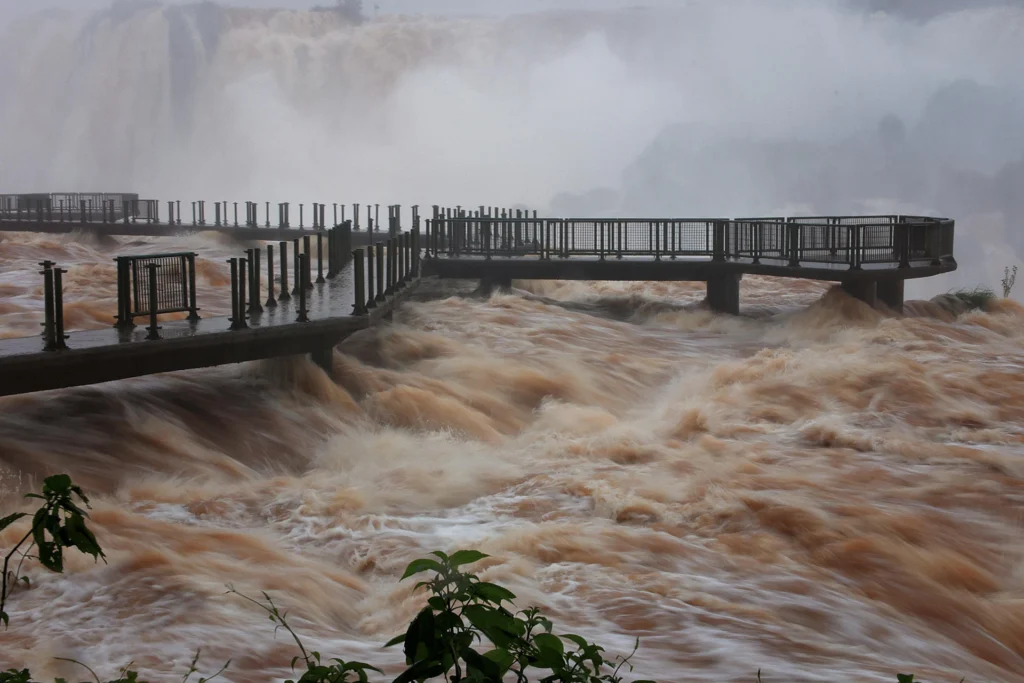
Paraná River floods inundate neighborhoods in Ciudad del Este, Paraguay, and Paso de la Patria, Argentina, forcing families to evacuate.

Flooding in Paraguay and Argentina’s Corrientes province has inundated homes and damaged infrastructure, with further rises in water levels possible.


Flooding along the Paraná River has forced about 4,200 families to evacuate in eastern Paraguay and inundated neighborhoods in Argentina’s Corrientes province, as authorities warn that further rainfall could worsen conditions in the coming days.

RELATED: Paraguay Evacuates 4,200 Families as Parana River Overflows

Ciudad del Este, in Paraguay, is among the hardest-hit areas, with more than 1,000 households affected. In Argentina, a breached flood barrier in Paso de la Patria has sent water hundreds of meters inland, submerging streets and creating additional safety risks.

Heavy rainfall across the Paraná River basin has prompted civil protection agencies and local authorities in both countries to assist displaced residents, distribute sandbags and establish temporary shelters.

In Paraguay’s Alto Paraná department, the neighborhood of Remansito in Ciudad del Este has suffered severe flooding. Around 35 families involved in recycling were forced to leave their homes after their plots were inundated.

🌊 La crecida del río Paraná obligó a evacuar a unas 4.200 familias en el este de Paraguay. ⚠️ En Ciudad del Este hay más de 1.000 hogares damnificados y 35 familias del barrio Remansito debieron abandonar sus viviendas. #teleSUR #Paraguay #22Oct #AméricaLatina… pic.twitter.com/0TV9HiUCkP

— teleSUR TV (@teleSURtv) October 23, 2026

Residents have blamed the rapid rise in water levels on the opening of floodgates at the Itaipu Binacional hydroelectric plant. The dam’s administration has rejected claims that the operation was the main cause of the flooding, saying the gates were opened in accordance with technical safety protocols for operational contingencies.

The emergency has also severely affected Paraguay’s Ñeembucú department, particularly the localities of Ayolas and Cerrito. Residents have organized community kitchens to provide food and basic supplies to evacuees.

Across the border, Paso de la Patria has become one of the most vulnerable areas in Corrientes province after an embankment near the Don Julián cabin area gave way. Water levels at the town’s port reached 7.79 meters.

The breach allowed floodwaters to advance as far as 300 meters inland, inundating the Los Pescadores, La Isla and Señoran neighborhoods, as well as areas around the Huajó stream.

The rising water has also submerged the Pinín Palma amphitheater and Isla de los Pájaros. The presence of potentially dangerous wildlife, including caimans, in residential areas has added to concerns over public safety. The flooding has also hit a town whose economy relies heavily on tourism and sport fishing.

Residents have described the difficulty of escaping the rising waters. Ismael Ali, who lives in Los Pescadores, said he was surrounded by floodwater with nowhere to go, while neighbors fled as best they could and tried to rescue their dogs.

Although the Paraná’s level in the Argentine sector fell by 40 centimeters on Friday, authorities warned that the decline might be temporary. Heavy storms continuing upstream in Brazil could cause water levels to rise by as much as another meter in the coming days.

Paraguay’s Directorate of Meteorology and Hydrology has forecast continued rainfall through the weekend, raising the risk of landslides. Municipal authorities and rescue teams in both countries are continuing to distribute sandbags, open temporary shelters and monitor riverside areas. Residents have been warned to remain alert for further rainfall and possible hail.

  •  

Three Earthquakes Strike Near Tibet After Deadly 7.0 Quake

Earthquake damage and rescue operations in Tibet following a magnitude 7.0 earthquake and subsequent tremors in China.

Three tremors struck near the epicenter of a deadly earthquake in Tibet as rescue teams continued relief efforts amid severe weather.


Three earthquakes measuring magnitudes 4.5, 4.1 and 4.2 struck near the epicenter of a magnitude 7.0 earthquake in China’s Tibet region between Friday night and Saturday morning, according to the China Earthquake Networks Center. The main quake has killed 16 people and injured 76, while rescue operations continue amid harsh weather and warnings of further tremors.

RELATED: Powerful 7.0 Earthquake in China’s Tibet Kills at Least 16 People

The first tremor struck Zaduo County in western China’s Qinghai province at 10:14 p.m. local time on Friday, at a depth of 10 kilometers. Two more earthquakes hit the same area and at the same depth on Saturday, at 6:39 a.m. and 8:07 a.m.

The tremors occurred near the epicenter of Thursday’s main earthquake in Baqing County, in Nagqu, Tibet. Seismological authorities have not yet confirmed whether the latest events are formally part of the same seismic sequence.

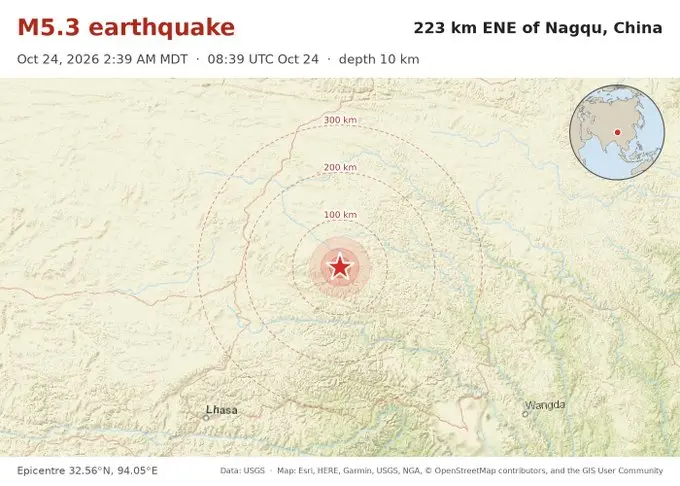
M5.3 likely aftershock – 223 km ENE of Nagqu, China

Oct 24 16:39 local time (18m ago)
Depth 10 kmhttps://t.co/A49zlMJPzH pic.twitter.com/PkqRxfBva0

— Earthquakes (@NewEarthquake) October 24, 2026

The official toll from the magnitude 7.0 earthquake remains at 16 dead and 76 injured. Authorities have also reported 339 homes destroyed or severely damaged, along with damage to 20 livestock facilities.

More than 5,000 personnel have been deployed to affected areas to conduct search and rescue operations and provide medical care and logistical support, state news agency Xinhua reported. Rescue teams have completed three rounds of house-to-house inspections without finding anyone reported missing.

Authorities have evacuated 12,489 residents and established at least 18 temporary shelters as a precaution.

🔊 A magnitude 7.0 earthquake hit Tibet, killing at least 16 and forcing thousands from their homes. It’s the strongest quake to hit China in nearly three years. More on the Reuters World News podcast https://t.co/dFVrexO5K2 pic.twitter.com/fu21iIGcM5

— Reuters (@Reuters) October 23, 2026

The emergency response is unfolding at an altitude of about 4,800 meters, where severe weather threatens to hamper relief efforts. China’s meteorological authorities forecast scattered snowfall for Saturday, with temperatures expected to fall as low as minus 9 degrees Celsius. Strong winds could further complicate travel and the installation of emergency shelters.

Chinese seismologists have warned that further perceptible aftershocks are likely in the coming days. Emergency teams are also monitoring secondary hazards, including potential rockfalls.

The magnitude 7.0 earthquake was the first of that strength recorded in China this year. It follows a January 2025 earthquake in Dingri County, Tibet, that killed at least 126 people.

  •  
❌