Companies will still be able to request higher exemption quotas if needed to maintain operations, while the government plans to introduce a new system allowing full exemptions for businesses that help recruit employees for military service.
Ukraine's Cabinet has opened the construction of underground arms production space to private investors, Prime Minister Serhii Koretskyi announced on 22 October, saying the rule applies from that day. A second decision eases imports for partner-funded weapons production.
Koretskyi said the change would add more of the space arms makers need, especially as Russian strikes intensify. On 9 December 2025, the Defense Ministry reported that more than UAH 1.5 billion (about $36 million) in budget support had let war-damaged defense firms restore operations. At the time, the ministry planned to relocate or duplicate the most critical plants, and underground complexes were under construction. The new model puts no additional burden on the state budget, Deputy Defense Minister Hanna Hvozdiar said. The bill still lands somewhere, though. Defense firms will buy, lease, or take the space for use, and companies working on state contracts are among those eligible. If they pay developers out of state-contract revenue, part of the cost could come back to the budget.
Developers build, arms makers move in
The changes to Cabinet resolution No. 1494 give private investors a simplified route to construction and permits, the ministry said. Developers can build protected facilities with their own or raised funds. Deadlines, terms of use, and the handover are set in a contract between investor and defense firm. The mechanism covers new sites as well as moving or expanding existing production. If a firm gets only part of a facility, that part must be at least 25% of the facility's total area and fit for production.
Explore further
One year of Ukrainian arms exports, and industry has questions: how much army gained, where Berlin office is, who joins joint ventures
Developers must sign deals with, among others, residents of Defence City, Ukraine's special legal regime for arms makers, holders of state defense contracts, and firms the ministry designates as critical.
Tax break for partner-funded arms production
Components for weapons production that international partners pay for will enter Ukraine free of import duty and VAT, Koretskyi said. He added that customs inspection and clearance would be simplified and sharply shortened through a "single window."
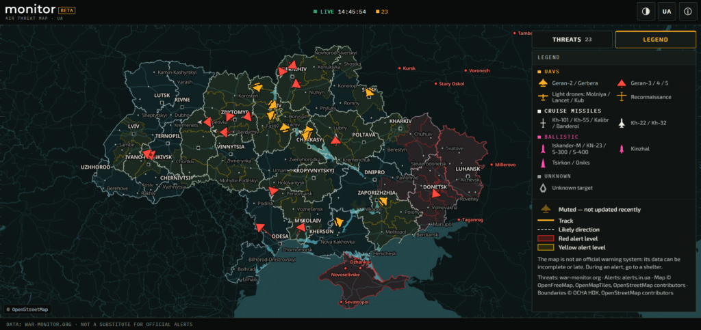
Ukrainians can now check a free live map of where Russian attack targets are flying, a Ukrainian air-threat monitoring project called monitor announced on X on 13 October. The beta pulls public reports of drones in flight into a single view and lays them over official air raid alerts.
Russia now flies jet-powered drones, and some switch off their engines before an attack and glide in. Over a hundred drones can arrive in one night. Yet since September, drone-only yellow alerts in some Oblasts no longer shut everything down. So during drone alerts, some Ukrainians now stay at their desks rather than in shelters. The new maps offers them a quick look at the sky from a phone, even on a weak signal.
What the map shows
The launch post described the service as one that tries to show where each target is, using open sources and algorithmic processing. It said the beta focuses on drones, with other targets to follow.
Screenshot from the Monitor map used to track aerial targets.
The drone data does not come from radar. The service draws on regional Telegram channels that post where drones and missiles are flying over their own oblasts. It cross-checks those posts to estimate what each target is, roughly where it is, and where it is heading, the project explains. The same page already lists cruise and ballistic missiles among the targets. It also says the map is free, ad-free, and needs no registration, and that it runs in a browser or on Telegram, designed to work on a phone with a weak signal.
A target log lists each drone’s district and course. Alert data comes from alerts.in.ua, and areas under alert turn red or yellow. The map refreshes about every 20 seconds while targets are airborne.
Screenshot from the Monitor map used to track aerial targets.
However, the developers warn that the dots are only estimates and show up late. Some targets slip through untracked. That is why “an empty map does not mean you are safe,” they wrote. When sirens sound, they urge people to rely on official signals and take shelter.
On 17 October, the Defense Ministry said that Ukraine’s Air Alert app now maps the approximate position and heading of some targets. These include cruise missiles, Banderol drone-launched missiles, and Shahed-type drones. The data comes straight from the Air Force over secure channels.
Screenshot from the Air Alert! map used to track aerial targets.
For security reasons, it carries no exact coordinates or real-time tracking and may lag. Ballistic missiles and anything faster than 2,000 km/h don’t appear at all. The ministry’s advice matches monitor’s: get to a shelter first, then check the map from there.

 Login